Trail across Bowen
Tuesday, July 04, 2006
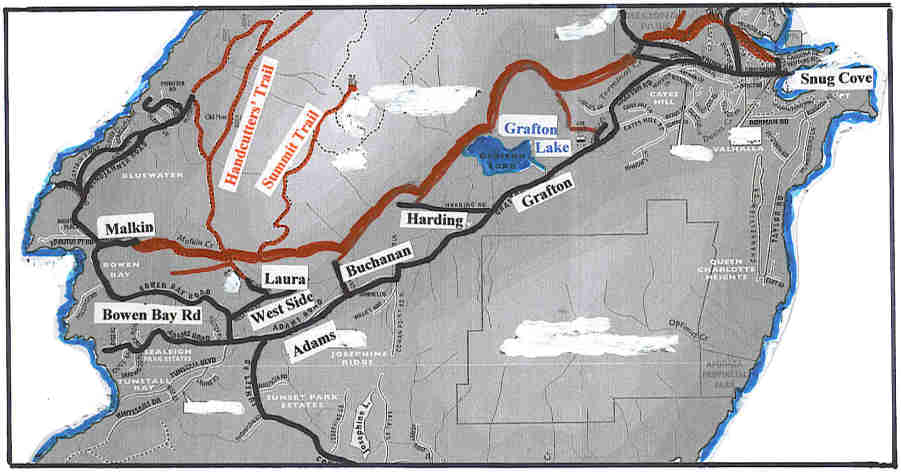
The hikers who get off the ferry in Snug Cove on Bowen Island step boldly out and head for Mount Gardner. After climbing its peak, they come back down and get on the ferry back home. They miss the jhoy of Bowen Island which has many trails to explore. Today, Doris and I set off to walk the Cross Tracks Trail on Bowen Island. This is one of my favourite trails on the island and last time we walked it, there had been two fallen trees, making passage difficult. So this morning we came equipped with a portable saw and pruning shears. The trail bears very few signs to indicate the way. Going west from the Snug Cove end, there is a very occasional sign on a tree, showing crossed skis and the words Grafton Lake, Bowen Bay, More usefully, there are often yellowish-green tapes at key intersections where you face a choice of directions.
.
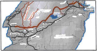 We caught the 9 o’clock Bowen Ferry and walked up the road from Snug Cove to the bus stop at the library. At about 9.25 the Blueridge bus came down the hill and deposited three passengers for the 9.30 ferry to Horseshoe Bay. It then turned round and picked us up. Peter King was the driver; he knows us well and we get a lot of Bowen history, information and politics from him. He asked where were going today. We told him Malkin Creek Road at Bowen Bay and we were on our way, just the two of us in our personal taxi. When he reached our turnoff, he drove us up Malkin Creek Road to its end. From here, we walked up Amelia Lane (the man at the end’s daughter is Amelia) to the End of Public Road sign. Just before the iron pin of 1580 Amelia a little path leads in to the right. We followed the path around and up to enter Mount Gardner Provincial Park.
The trail started up along the valley of Malkin Creek. The undergrowth was beautiful with the sun streaming through the tall conifers. In about fifteen minutes we came to a major junction. The signed Handcutters’ Trail led off at an upward angle to the left. The trail to the right led first to a signed trail to the Top of Bowen Hill and then to another signed trail to Laura Road. However, we carried straight on following red markers and later a summit marker leading to the peak of Mount Gardner. (We also crossed the Top of Bowen Hill and Laura trails on our way.
We climbed for about ten minutes to where the trail forked. We took the red-taped lower trail but both branches quickly rejoined anyhow. Almost immediately after the rejoining, a trail led off to the right. (Green tapes showed the way in and a green tape on the main trail bushes told travellers in the opposite direction to go down at this point.) The new trail soon dropped down to a good viewpoint and we took a refreshment break. Some houses of West Side Road were below us and Adams Road in the Grafton Lake Valley below that. We could see Sunset Road making its way up the hill opposite with Bob’s Knob of Quarry Park behind it. We continued on the trail, following the lower slopes of Mount Gardner but keeping above the developed areas. On the way, we came to the place which had been almost blocked by two fallen trees on our last visit. Someone had partially cleared it but we spent about 45 minutes cutting and clearing and left the area feeling that it was now definitely open. We passed through trees above an old gravel pit, stopping at a viewpoint for lunch, and came down to a crossing trail. To the west is Eddie’s Pit, with workshops and abandoned vehicles at the top of Buchanan Road off Adams Road in the valley. The land is private but we once took a bus from Snug Cove to Buchanan Road, walked up the hill to Eddie’s, asked permission to go to the trail and were shown to it.
We continued east on the trail from Eddie’s, again hugging the lower slopes of Mount Gardner but seeing signs of private trails on the right leading to housing at the higher levels of recent Harding Road developments. Eventually we came down to a wide trail crossing in front of us. To the west, the trail soon ends at the back of a Harding Street house with the road visible across the side yard.. We turned east and dropped down to the Grafton Lake surroundings. In the winter, we have twice had to cross fast running creeks and bushwhack through areas above flooded trails to continue here. However, today all was bone dry and we reached the trail that follows the north side of Grafton Lake. We stopped near the end of the straight section to enjoy the viewpoint.
We took the first trail on the left where the lake view disappeared and the perimeter path curved right. (There is a later trail on the left, but it is steeper and goes to the same point.) We went briefly but steeply up, crossed a pass and dropped down on the far side following a rocky creek bed. This is Guild Creek, dry today, but in the winter it flows abundantly and travel can be very difficult. After reaching the bottom, the rest of our journey was clear sailing. A wide clear path led through woods. A post on the right and red ribbons announced Duncan’s Hat, the popular name of a hill officially called Conical Hill. Soon after that, we came to a trail leading off on the right, signed as Fitness Centre. The reference eludes me, since it leads to a track going out to Connolly Road by the Fire Hall. We carried straight on passing a sign saying Please No Motorized Vehicles. Here we were passing through farmland where the owner indicates you are welcome to walk, staying on the trail. We came out to a corner in Carter Road, followed it down to Mount Gardner Road and crossed to the Fish Hatchery. This seemed a good time to use the toilets available there. The rest of our way was very familiar territory. We went straight ahead, turned first right onto Hatchery Trail and crossed directly over Miller Road to pass through Crippen Park to Snug Cove and the 3 o’clock ferry.
Return to Further Walks
Archives
![]()